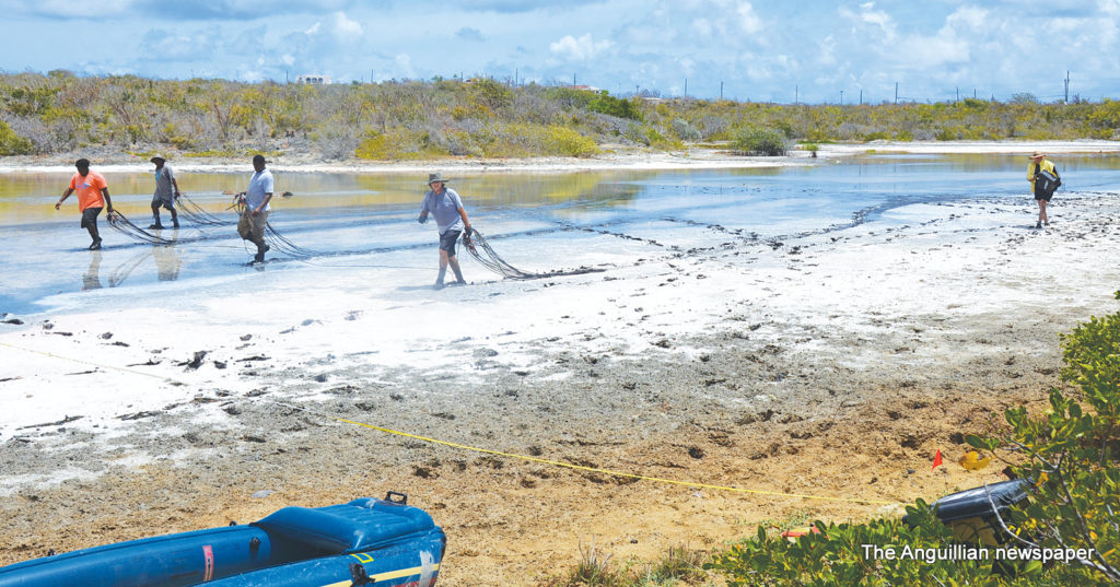
The East End Pond is almost dry as a result of the prolonged severe drought affecting Anguilla. This is generally regarded as a concern for the scenic environment and the bird life there.
It is, however, a good opportunity for researchers to see what can be done when, after heavy rainfall, the pond overflows its banks sending torrents of water across the public road and into settlement areas.
A case in point was in November 1999 when, during Hurricane Lenny, the pond was heavily flooded by run-off water mainly from the hillsides which then almost covered the rooftops of at least two nearby buildings.
Two researchers have just completed an assessment of the depth of the pond and the volume of silt or clay there – believed to be contributing factors to its flooding following heavy rainfall. They are Mr. Sandy Nettles and Mr. Paul Chounard of Ocean Earth Technologies Ltd, a Florida-based company. They have since left the island but were assisted by Devon Carter, Tashim Fleming and Aaron Richardson of the Anguilla National Trust.
The work in the pond, which is expected to continue later, is part of a project called: “Restoring and safeguarding the wetlands of the Caribbean Overseas Territories through the United Kingdom’s Darwin-Plus Initiative”. It is a cross-territory project led by the UK’s Royal Society for the Protection of Birds. The territories involved in the project are Anguilla, Montserrat and the Turks & Caicos Islands.
The total project funding amounts to just-under 268,000 pounds sterling of which almost 86,000 pounds will finance the work in Anguilla through the Anguilla National Trust. This is according to Ms. Farah Mukhida, Executive Director of the National Trust.
Mr. Nettles, the lead researcher, spoke to The Anguillian newspaper about the work at the pond: “The concern is the flooding issue in the East End area,” he explained. “The pond is obviously a depression surrounded by high ridges and all the water from those ridges gradually works down into the pond…and there is no place for it to go. One of the ideas I have, as a geologist, is to look at how thick the clay is because clay is part of the problem. It seals off the limestone and reduces the ability of the water to move out of the area.
 “We were running geo-physics…basically stretching long cables out in a straight line with a bunch of electrodes on them. We sparked electric currents through the ground. We read the speed of the path of the electricity and the farther apart the electrodes were, the deeper we saw – some areas thirty feet and others under fifty feet of depth. We looked at the geology underneath the pond over a large area. We did about a 150-foot grid running from west to east across the pond and then three lines running down the length of the pond through the centre.”
The geologist added: “I will take all that data where the thickness of the clay is and see what the rock is. It will also show me whether there are any channels or sink holes that have been filled –just naturally or by man – and we will be able to get an idea about the amount of material that has to be removed; where the thickest and thinness parts are; and how to remove that impermeable layer. Even though it might not be possible to stop the flooding, hopefully by removing the clay or opening up the very porous limestone, the water would drain away much faster.”
Mr. Nettles observed that due to the far distance of the pond from the sea, and the expense it would entail, it would not be possible to construct a drain from one point to the other.
He pointed out that while the East End pond was a challenge, he had worked successfully on a number of other ponds at the western end of Anguilla with good results.
In relation to the East End Pond, a matter which often comes up is the filling of part of the pond with a quantity of marl under the administration of the late Mr. Ronald Webster. The intention was said to create more parking space for vehicles. Whether some of that filling material eventually made its way down through the pond is anyone’s guess.
A similar filling was done at the Island Harbour Pond, now commonly referred to as “the pond fill” but which floods during heavy rain and into the adjoining public road.


