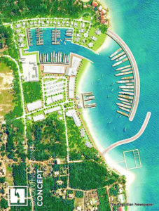
 As reported by The Anguillian newspaper recently, Edgewater Resources LLC, commissioned by the Anguilla Government, has identified five possible sites where marinas can be built as docking facilities for some of the world’s renowned superyachts.
Those proposed sites in the now published Feasibility Study, are Blowing Point, Sandy Ground, Scrub Island, Rendezvous and Little Harbour.
Several days ago, The Anguillian was engaged in a conversation with taxi-drivers and other persons at the Bowing Point Port and found that there were diverse views on the pros and cons of having a superyacht marina there.
The main points of the conversation were about the current use of the harbour as a passenger terminal for large numbers of persons travelling daily between Anguilla and St. Martin/St. Maarten; the planned further development of the port including a new passenger terminal to replace the one destroyed by Hurricane Irma in September 2017; the planned substantial extension of the parking lot which so far necessitated the demolition of at least two buildings; the anchorage space for the ferry boats; and the mass of hard coral reef taking up a large portion of the harbour at the eastern end.
The conversation was carried on without the participants having in front of them a concept map and explanations about the proposed superyacht marina there, as presented by the consultants. Below is the Blowing Point Concept extracted from the Feasibility Study submitted by Edgewater Resources LLC to the Government of Anguilla.
The Blowing Point Concept
The proposed Blowing Point location is centrally located on the southern side of Anguilla’s main island, and is home to the existing ferry terminal docks, where travelers arrive when coming to Anguilla by sea. The Country’s Security Customs building is located immediately upland of the existing ferry terminal docks. Westward of the existing ferry terminal docks is a beach extending roughly 427 meters (1,400 feet) in length with the remains of a former dolphin exhibit observatory sanctuary that was destroyed in the 2017 recent hurricanes last year (Hurricane Irma, September 2017). There are several existing structures that line the beach westward of the ferry terminal docks. The beach also extends eastward roughly 305 meters (1,000 feet)’ in length, where it meets the landward end of a coral reef formation. Two reef formations extend outward from either end of the beach creating a somewhat natural harbour/ basin. Within this natural harbour is a mooring field where locals use mooring buoys to secure smaller [(less than 12 meters/ (40 feet)] vessels while they are not in use. Approximately 76 meters (250 feet) inland of the eastern beach is a roughly 2 hectares (5 acres) existing salt pond. The site’s coral reef and salt pond were surveyed and summarized as part of the environmental considerations section of this report. Existing water depths are favorable at this location; however, it is anticipated that dredging will be required to create an entrance channel and outer mooring basin.
The conceptual site plan for Blowing Point, utilizes the observed natural wave break that is present due to the existing reef formation, as well as the inland salt pond. This location encompasses a much smaller footprint when compared to Sandy Ground; however, it introduces the idea of two large rubble mound breakwaters that will enhance the existing natural harbour and create a marine climate that is suitable for mooring megayachts. The concept plan includes the creation of an outer mooring basin for megayachts up to 91 meters (300 feet) and an inner marina basin that utilizes the existing salt pond. The inner basin would handle vessels up to 31 meters (100 feet) in length, in addition to a number of smaller slips ranging from 12 to 24 meters (40 to 80 feet) in length. Development of the uplands should also include the addition of a maritime museum to preserve, and celebrate the legendary captains, boat builders, regattas, and maritime heritage from Anguilla’s rich history.


