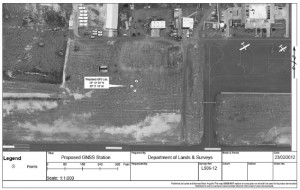
 UNAVCO (a non-profit university-governed consortium, facilitates geosciences research and education organization) the representative of Continuously Operating Caribbean GPS Observational Network (COCONet) is a US National Science Foundation funded project. The primary purpose of this project is to enhance the scientific understanding of the Caribbean tectonic plate. The COCONet GPS station on Anguilla will form part of existing COCONet GPS stations around the Caribbean region.
COCONet will establish a GPS station on Anguilla at the Clayton J Lloyd International Airport. The project will:
o Aid with the monitoring, understanding, and the prediction of earthquakes, hurricanes, floods, volcanoes, tsunamis and landslides on the island and in the Pan-Caribbean region.
o Provide free, open-format data and data products for researchers, educators, students, and the private sector for a variety of purposes, including science, research, local surveying, infrastructure monitoring, event response, and the creation of a comprehensive register of land-use.
o Act as an observation station that can be used for the better understanding and forecasting of airborne moisture associated with the yearly Hurricane cycle.
o Act as a meteorological station that will measure wind speed, direction, humidity and precipitation.
The COCONet project is under the direction of Dr. M. Meghan Miller, the representative for UNAVCO. The principal contacts for GOA and AASPA are Mr. Gifford Connor, Director, Department of Lands and Surveys, Mr. Leslie Jasen Hodge, Director Designate, Department of Lands and Surveys, Mr. Remington Lake, Acting CEO of AASPA and Mr. Lindon Hodge, Acting Airport Manager, respectively.
– Press Release
(Published without editing by The Anguillian newspaper.)


